|
Introduction
The Geostationary Operational Environmental Satellite
(GOES) series of satellites has its roots in the early 1960's
when NASA's Research and Development Application Technology
Satellite (ATS) flew the first Spin Scan Cloudcover Camera
(SSCC). The SSCC was developed by Dr. Verner Suomi of the
University of Wisconsin, and as a result of the tremendous
success to the value of weather satellites due to his invention,
Dr. Suomi is regarded as the father of satellite meteorology. It
was capable of taking Earth disk scans every half hour using the
spinning motion of the spacecraft.
The success of the ATS-1 and 3 geostationary
satellites led to the development of the first operational
meteorological satellites called the Synchronous Meteorological
Satellites (SMS) during the 1970's. These were equipped with the
Visible Spin Scan Radiometer (VISSR). NASA procured, built and
launched three more satellites, called by its modern day name of
Geostationary Operational Environmental Satellite (GOES). After
these were checked out they were handed over to the National
Oceanic and Atmospheric Administration (NOAA) for daily
operations. NOAA assumes responsibility for the command and
control of the satellite, transmission of data, and the archive
and dissemination of the data and its derived products to the
user community.
Beginning with GOES-4, a modified instrument
called the Visible Spin Scan Radiometer Atmospheric Sounder (VAS)
was added to measure temperature and water vapor profiles within
the atmospheric boundary, along with visible and infrared images
of the earth.
The second generation of GOES satellites commenced with the
launch of GOES-8 on April 13, 1994. Known as the Next Generation
of GOES these satellites were totally redesigned from the ground
up. A three-axis stabilized body replaced the older spinning GOES
satellites which allows the instruments to be in constant view of
the Earth and its atmosphere. The VAS instrument was replaced by
a much improved Imager and Sounder. Additional improvements were
made to this series of GOES satellites operating over the last 20
years. The last one of the series is GOES-15 positioned over 135
west longitude.
The third major generation of the GOES series commenced with
the launch of GOES-R on November 19, 2016. It replaced the
GOES-13 satellite as the latest operational GOES-East satellite
on December 18, 2017. GOES-S launched on March 1, 2018, and is
now operational as GOES-West. Two more satellites, GOES-T and
GOES-U, will round out the current series, which will provide
critical weather observations well into the 2030’s. For
complete information on the GOES-R Series please go to www.goes-r.gov.
NOAA's National Centers for Environmental
Information (NCEI) is responsible for the long term archive,
preservation, stewarship and access of the GOES data, while the
NOAA's National Environmental Satellite, Data, and Information
Service (NESDIS) operates the satellites and is responsible for
providing real-time data and products to the user community.
Where Polar-orbiting Operational
Environmental Satellites (POES) provide daily global coverage
for analyzing long-term climatic and environmental trends, the
GOES satellites' primary mission is to monitor the atmosphere
for severe weather development such as tornadoes, flash floods,
hail storms and hurricanes. When these conditions develop, the
GOES satellites can track storms on a minute to minute basis.
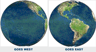
The GOES satellite is positioned 35,790 km
(22,240 statute miles) above the equator allowing it to view a
major portion of the Western Hemisphere including southern
Canada, the contiguous 48 states, major portions of the eastern
Pacific Ocean and western Atlantic Ocean and Central and South
America. Because the Atlantic and Pacific basins strongly
impact the weather over the United States, coverage is
typically provided by two GOES spacecraft, one at -75.0
Longitude (GOES East) and the other at -135.0 Longitude (GOES
West).
The combined footprint (radiometric coverage
and communications range) of the two spacecraft encompasses
Earth's full disk about the meridian approximately in the
center of the continental United States.
Below is a table listing satellite name, launch date, period of public availability of GOES primary imager data, approximate position of the satellite subpoint during the operational life of the satellite, and name of instrument of each satellite. Please note that small gaps in the database can occur due to a variety of reasons. Please contact the CLASS Help Desk for more details or questions.
| Satellite |
Launch
Date |
Start
Date |
End
Date |
Approx.
Position |
Instrument
Earth facing only
|
SMS-1+ |
05/17/74 |
01/26/79 |
04/19/79 |
-75 |
VISSR |
SMS-2+ |
02/06/75 |
04/19/79 |
08/05/81 |
-75 |
VISSR |
GOES-1 |
10/16/75 |
11/29/82 |
05/31/83 |
Variable++ |
VISSR |
GOES-2 |
06/16/77 |
02/20/78 |
01/26/79 |
-75 |
VISSR |
GOES-3 |
06/16/78 |
11/20/78 |
03/05/81 |
-135 |
VISSR |
GOES-4 |
09/09/80 |
03/05/81 |
11/26/82 |
-135 |
VAS |
GOES-5 |
05/15/81 |
08/05/81 |
07/30/84 |
-75 |
VAS |
GOES-6 |
04/28/83 |
06/01/83 |
01/21/89 |
Variable++ |
VAS |
GOES-7 |
02/26/87 |
03/25/87 |
01/09/96 |
Variable++ |
VAS |
GOES-8 |
04/13/94 |
09/01/94 |
04/01/03 |
-75 |
Imager/Sounder |
GOES-9 |
05/23/95 |
01/09/96 |
07/21/98 |
-135 |
Imager/Sounder |
GOES-9* |
|
04/23/03 |
07/13/04 |
150 |
Imager/Sounder |
GOES-10 |
04/25/97 |
07/21/98 |
06/21/06 |
-135 |
Imager/Sounder |
GOES-11 |
05/03/00 |
06/21/06 |
12/06/11 |
-135 |
Imager/Sounder |
GOES-12 |
07/23/01 |
04/01/03 |
04/14/10 |
-75 |
Imager/Sounder |
GOES-13 |
05/24/06 |
04/14/10
10/18/12**
|
09/23/12
01/08/18
|
-75 |
Imager/Sounder |
GOES-14^ |
06/27/09 |
08/14/12 |
11/01/12 |
-105 |
Imager/Sounder |
GOES-15 |
03/04/10 |
08/02/11 |
03/02/20 |
-135 |
Imager/Sounder |
GOES-16 |
11/19/16 |
02/28/17 |
04/07/25 |
-75.2 |
ABI/GLM |
GOES-17 |
03/01/18 |
08/27/18 |
01/10/23 |
-137.2 |
ABI/GLM |
GOES-18 |
03/01/22 |
05/11/22 |
Present |
-137.0 |
ABI/GLM |
GOES-19 |
06/25/24 |
04/04/25 |
Present |
-75.2 |
ABI/GLM |
Legend
+ SMS-1 and SMS-2 contain large data gaps in the
period of record
++ Satellites were moved to different
orbital positions to fulfill seasonal operational needs during
times when there was a single satellite configuration.
*
GOES-9 replacement for GMS-5 over western Pacific - limited
data in CLASS
** GOES-13 data gap from Sep 23, 2012 to
Oct 18, 2012 due to an anomaly
^ GOES-14 placed into
service during GOES-13 outage.
The table below lists GOES-14 operation periods for GOES-R
testing support
GOES-14
Super Rapid Scan Operations |
| Start
Date |
End Date |
05/23/13 |
06/13/13 |
08/07/13 |
08/29/13 |
05/06/14 |
05/19/14 |
08/14/14 |
08/29/14 |
04/29/15 |
06/15/15 |
|
The GOES information that follows is specific to GOES-8
through GOES-15. Information and links to technical
documentation for the older satellites (GOES-7 on back), is
in the Comphrehensive Information section near the bottom of
the page. GOES-R Series information and documentation can be
found at www.goes-r.gov.
|
|
Application
The objective of the GOES satellites is
to provide continuous, timely and high-quality environmental
and atmospheric observations over much of the Western
Hemisphere to enable forecasters to more accurately predict
weather conditions and monitor and track severe storms. GOES
data are used in a number of forecast situations such as
estimating heavy rainfall, measuring movement and strengths
of tropical storms, tracking volcanic plumes for aviation
safety, measuring sea-surface temperatures, and much more.
Since the GOES data archive extends well over three decades,
its applications in long-term climate change studies are
being used by scientists around the world. |
| Data
Acqusition
GOES Data Acquisition Introduction
The GOES Support System includes the
Command and Data Acquisition (CDA) Station at Wallops
Island, VA, and the NOAA Satellite Operations Facility
(NSOF) at Suitland, MD. At the CDA Station, raw instrument
data and telemetry are received from the satellite and
processed into calibrated, earth-located datasets and
converted into GOES VARiable data format (GVAR). The
processed GOES data is then rebroadcast to the satellite
along with spacecraft command schedules. The GVAR data in
turn are then broadcast earthward to direct readout users
equipped antenna, hardware and software. NSOF is responsible
for the overall safety of the spacecraft, scheduling of the
instruments, data quality and performance. Continuous
monitoring and checks are conducted on orbital position,
image navigation and registration, and various subsystems
including primary imager and sounder instruments. It is also
responsible for planning and operating the ground system
equipment for GVAR acquisition at NESDIS, the initial stage
of product processing. The Office of Satellite Processing
and Operations (OSPO) manages and directs the operation of
the central ground facilities which ingest, process, and
distribute environmental satellite data and derived products
to domestic and foreign users.
GOES System Functions and Instruments
The GOES spacecraft performs three major
functions:
-
Environmental Sensing: Acquisition,
processing and dissemination of imaging and sounding data,
independent of imaging data processes and the (in-situ)
space environment monitoring data, and measurement of the
near-earth space weather.
-
Data Collection: Receive data from
earth surface-based Data Collection Platforms (DCPs) and
relay to various acquisition stations.
-
Data Broadcast: Continuous relay of
weather facsimile and other meteorological data to
independent users, research and educational institutions;
relay of distress signals from aircraft or marine vessels
to the search and rescue ground station of the search and
rescue satellite-aided tracking system.
Each mission function is supported or
performed by components of the GOES payloads:
Environmental Sensing:
Data Collection:
Data Collection System (DCS)
Data Broadcast
The remote sensing function is carried
out by the 5-channel Imager and 19-channel Sounder. The
acquisition of sensed data and its handling, processing, and
final distribution are performed in real-time to meet
observation time and timeliness requirements, including
revisit cycles. Remotely sensed data are obtained over a
wide range of areas of the western hemisphere, encompassing
the earth's disk, selected sectors and small areas. Area
coverage also includes the visibility needed to relay
signals and data from ground transmitters and platforms to
central stations and end users. |
| Imager
Imager Introduction
The Imager instrument is
designed to sense radiant and solar-reflected energy from
sampled areas of the Earth's surface and atmosphere. The
Imager's five spectral channels simultaneously sweep an 8 km
north-south (N/S) longitudinal swath along an east-west
(E/W) latitudinal path by means of a two-axis gimballed
mirror scan system. Beamsplitters separate the spectral
channels into the various IR detector sets.
The primary characteristics of
the imager are defined in the following tables:
Imager Instrument Characteristics:
|
Channel
|
Detector Type
|
Nominal Square IGFOV at nadir
|
|
1 (Visible)
|
Silicon
|
1 km
|
|
2 (Shortwave)
|
InSb
|
4 km
|
|
3 (Moisture)
|
HgCdTe
|
8 km (4 km GOES 12/13/14/15)
|
|
4 (Longwave 1)
|
HgCdTe
|
4 km
|
|
5 and 6 (Longwave 2)
|
HgCdTe
|
4 km
|
Imager Instrument Parameters:
|
Parameter
|
Performance
|
|
FOV defining element
|
Detector
|
|
Channel-to-channel alignment
|
28 µ rad (1.0 km) at nadir
|
|
Radiometric calibration
|
300 K internal blackbody and space view
|
|
Signal quantizing
|
10 bits, all channels
|
|
Scan capability
|
Full earth, sector, area
|
|
Output data rate
|
2,620,800 b/s
|
|
Imaging areas
|
20.8° E/W by 19° N/S
|
Imaging Channels Allocation:
|
Channel Number
|
Wavelength Range (µm)
|
Range of Measurement
|
|
1
|
0.55 to 0.75
|
1.6 to 100% albedo
|
|
2 (GOES 8/9/10)
2 (GOES 11/12)
|
3.80 to 4.00
3.80 to 4.00
|
4 to 320 K
4 to 335 K
|
|
3 (GOES 8/9/10/11)
3 (GOES 12/13/14/15)
|
6.50 to 7.00
5.77 to 7.33
|
4 to 320 K
|
|
4
|
10.20 to 11.20
|
4 to 320 K
|
|
5 (GOES 8/9/10/11)
|
11.50 to 12.50
|
4 to 320 K
|
|
6 (GOES 12/13/14/15)
|
12.96 to 13.72
|
4 to 320 K
|
Imager Performance Summary:
|
Parameter
|
Performance
|
|
System absolute accuracy
|
Infrared channel ≤ 1 K
Visible channel ± 5% of
maximum scene radiance
|
|
System relative accuracy
|
Line to line ≤0.1 K
Detector to detector ≤0.2 K
Channel to channel ≤0.2 K
Blackbody
calibration to calibration ≤0.35 K
|
|
Star sense area
|
21° N/S by 23° E/W
|
|
Imaging rate
|
Full earth ≤ 26 min
|
|
Time delay
|
≤3 min
|
|
Fixed Earth projection and grid duration
|
24 hours
|
|
Data timeliness
Spacecraft processing
Data coincidence
|
≤30 s
≤5 s
|
|
Imaging periods
Image navigation accuracy @
nadir
Registration within an image*
Registration between repeated images*
* For spec orbit
|
25 min
15 min
90
min
24 h
48 h
|
Noon ±8 hrs
4 km
50 µrad
53 µrad
84 µrad
168 µrad
210
µrad
|
Midnight ±4 hrs
6 km
50 µrad
70 µrad
105 µrad
168 µrad
210
µrad
|
|
Channel-to-channel registration
|
|
28 µrad
|
50 µrad
(IR only)
|
Imager Scanning Characteristics
The Imager scans predetermined
areas in alternate directions on alternate lines. The
imaging area is defined by a coordinate system related to
the instrument's orthogonal scan axis. During imaging
operations a scan line is generated by rotating the scanning
mirror in the east-west direction while concurrently
sampling each of the active imaging detectors. At the end of
the line, the Imager scan mirror performs a turnaround,
which involves stepping the mirror to the next scan line and
reversing the direction of the mirror. The next scan is then
acquired by rotating the scanning mirror in the opposite,
west-east direction, again with concurrent detector
sampling. Detector sampling occurs within the context of a
repeating data block format. In general, all visible
detectors are sampled four times for each data block (four
times 1 km wide); while each of the active IR detectors is
sampled once per data block (one times 4 km wide).
There are three operational
imaging modes which satisfy a number of requirements defined
by the NOAA NESDIS/NWS Study Group. The operational modes
are designated as Routine, Rapid Scan and Super Rapid Scan.
The tables below provide information on coverage, scan
duration and scan times for GOES-East and GOES-WEST during
Routine operational mode.
GOES-EAST Imager Scan Sectors
in Routine Mode
|
Frame Name
|
Boundaries
|
Duration
(mm:ss)
|
Scan Times
(UTC)
|
|
Full Earth
|
Earth Edge
|
26:16
|
0245, 0545, 0845, etc
|
|
Extended N Hemisphere
|
20S-66N/45-120W
|
14:16
|
xx15, xx45
|
|
Southern Hemisphere
|
20-50S/30-120W
|
4:53
|
xx10, xx40
|
|
CONUS
|
14-60N/60-125W
|
4:45
|
xx00, xx30
|
GOES-WEST Imager Scan Sectors
in Routine Mode
|
Frame Name
|
Boundaries
|
Duration
(mm:ss)
|
Scan Times
(UTC)
|
|
Full Earth
|
Earth Edge
|
26:10
|
0000, 0300, 0600, etc
|
|
Northern Hemisphere
|
0-66N/90W-170E
|
9:00
|
xx00, xx30
|
|
Southern Hemisphere
|
0-45S/115W-170E
|
7:00
|
xx22, xx52
|
|
PACUS
|
12-60N/90-175W
|
5:00
|
xx15, xx45
|
During GOES Rapid Scan
Operations (RSO), four views of the continental United
States (CONUS) are provided at approximately 7.5 minute
intervals in a half hour period. A northern hemisphere scan
for both GOES East and GOES West satellites is also included
in the 30 minute cycle. This yields eight views of the
continental U.S. per hour.
During GOES Super Rapid Scan
Operations (SRSO), approximately 10 one-minute interval
scans are provided every half hour using prescribed 1000 x
1000 km sectors. The remaining time in the half hour cycle
is devoted to scans of the northern hemisphere and CONUS (or
sub-CONUS for GOES-WEST).
When GOES RSO or SRSO is
utilized, most of the southern hemisphere is not scanned.
Imager Data Characteristics
GOES data transmitted from the
satellites and received by users with ground receiving
equipment is called GVAR data. This format is primarily used
to transmit meteorological data measured by the Imager and
Sounder instruments and is archived in this format but
rarely provided in this format to users of retrospective
data due to its complex nature.
The GVAR format has its origins
in the Operational VAS Mode AAA format, which featured a
fixed length format composed of 12 equal size blocks of
data. These blocks were transmitted synchronously with the
spin of the earlier GOES (i.e. one complete 12 block
sequence occurred for each rotation of the satellite.
With the launch of GOES-8 in
April 1994, the spin-scan satellites were replaced by
three-axis stabilized GOES. The continued use of the old
transmission format would have been detrimental to the
operational capabilities of these satellites. Therefore, the
GVAR format was developed. GVAR maintained as much
commonality with the Mode AAA reception equipment that many
users had invested in and permitted full use of the advanced
data transmission technology.
Imager Calibration
The raw data in the visible channel are relativized and
normalized at the CDA, but no calibration is applied. The
raw data in the IR channels are calibrated using spacelooks
and a heated internal blackbody. The spacelook calibration
positions the scanning mirror at an extreme E-W coordinate
permitting a view of space. The frequency of these
spacelooks depends on the activity of the instrument. The
rates vary from once every second to once every 36.6
seconds. A Blackbody calibration sequence is initiated every
30 minutes. During the sequence, the scanning mirror is
rotated in the N-S direction through an angle of
approximately 180 degrees to present a view of the Blackbody
surface to the imaging detectors. The Blackbody surface
temperature is maintained at a nominal 290Ëš K. For more
information on GOES calibration see https://www.ospo.noaa.gov/Operations_/GOES/calibration/index(archived).html.
|
| Sounder
Sounder Introduction
The Sounder operates independently of the
Imager and is designed to measure atmospheric temperature
and moisture across large regions of the western hemisphere.
The instrument contains 18 IR channels and one visible
channel. There are four detectors for each band. Each
detector's Field of View (FOV) is 8 km at nadir. The scan
swath width is 40 km wide (N-S). The infrared spectral
definition is provided by a rotating filter wheel that
brings selected filters into the optical path of the
detector assembly. Filters in three spectral ranges,
longwave (12µm to 14.7µm), midwave (6.5µm to 11µm), and
shortwave (3.7µm to 4.6µm), are arranged on the wheel for
efficient use of sample time and optimal channel
co-registration. The rotation of the filter wheel is
synchronized with the stepping motion scan mirror. The
visible channel (0.67µm) is not part of the filter wheel but
is a separate set of uncooled silicon detectors having the
same field of view size and spacing. These detectors are
sampled at the same time as IR channels 3, 11, and 18,
providing registration of all sounding data.
The primary characteristics of the
sounder are defined in the following tables:
Sounder Instrument Characteristics:
|
Channels
|
Detector Type
|
Nominal Circular IGFOV (µrad)
|
|
1 to 7 (LW IR)
|
HgCdTe
|
242
|
|
8 to 12 (MW IR)
|
HgCdTe
|
242
|
|
13 to 18 (SW IR)
|
InSb
|
242
|
|
19 (visible)
|
Silicon
|
242
|
|
Star sense
|
Silicon
|
28*
|
*square detectors
Sounder Instrument Parameters:
|
Parameter
|
Performance
|
|
FOV defining element
|
Field stop
|
|
Telescope aperture
|
31.1-cm (12.2-in) diameter
|
|
Channel definition
|
Interference filters
|
|
Radiometric calibration
|
Space and 300 K IR blackbody
|
|
Field sampling
|
Four areas N/S on 280 µrad centers
|
|
Scan step angle
|
280 µrad (10-km nadir) EW
|
|
Step and dwell time
|
0.1, 0.2, 0.4s adjustable
|
|
Scan capability
|
Full earth and space
|
|
Sounding areas
|
10 km by 40 km to 60° N/S and 60° E/W
|
|
Signal quantizing
|
13 bits, all channels
|
|
Output data rate
|
40 kb/s
|
|
Channel-to-channel alignment
|
22 µrad
|
Sounder Detectors Channel Allocation:
|
Detector
|
Channel Number
|
Wavelength (Åm)
|
Wave No. (cm-1)
|
|
Longwave
|
1
2
3
4
5
6
7
|
14.71
14.37
14.06
13.64
13.37
12.66
12.02
|
680
696
711
733
748
790
832
|
|
Midwave
|
8
9
10
11
12
|
11.03
9.71
7.43
7.02
6.51
|
907
1030
1345
1425
1535
|
|
Shortwave
|
13
14
15
16
17
18
|
4.57
4.52
4.45
4.13
3.98
3.74
|
2188
2210
2248
2420
2513
2671
|
|
Visible
|
19
|
0.70
|
14367
|
Sounder Performance Summary:
|
Parameter
|
Performance
|
|
System absolute accuracy
|
Infrared channel ≤ 1 K
Visible channel ± 5% of
maximum scene radiance
|
|
System relative accuracy
|
Line to line ≤25 K
Detector to detector ≤40 K
Channel to channel ≤29 K
Blackbody calibration
to calibration ≤60 K
|
|
Star sense area
|
21° N/S by 23° E/W
|
|
Sounding rate
|
3000 by 3000 km ≤ 42 min
|
|
Time delay
|
≤3 min
|
|
Visible channel data quantization
|
≤1% albedo
|
|
Infrared channel data quantization
|
1/3 specified noise equivalent radiance difference
(NE∆N)
|
|
Data timeliness
Spacecraft processing
|
≤ 30 s
|
|
Sounding periods
Image navigation accuracy
at nadir
Registration within 120 minute sounding
Registration between repeated soundings
|
120 min
24 h
|
Noon ±8 hrs
10 km
84µrad
280µrad
|
Midnight ±4 hrs
10 km
112µrad
280µrad
|
|
channel-to-channel registration
|
|
28µrad
|
28µrad
|
Sounder Scanning Characteristics
Like the Imager, the Sounder
scans the selected image area in alternate directions on
alternate lines. This area is defined by scan coordinates
which relate to the latitude and longitude for the northwest
corner and southeast corner. The Sounder, however, provides
additional scanning features that are not employed on the
Imager. This instrument provides the capability to dwell on
a particular location for a pre-programmed time period.
These dwell times are 0.1, 0.2, or 0.4 seconds for one, two,
or four data blocks. The Sounder also employs two N/S
scanning modes referred to as the single and double-step
modes. When in the single-step mode, the scan mirror steps
the equivalent of one output scan line in the N-S direction
each time an E-W or W-E scan completes. In the double-step
mode, the scan mirror steps two output scan lines in the N-S
direction for each E-W or W-E scan. This mode is also
referred to as the skip-line mode and will only scan an
image area with a dwell of 0.1 second. The single-step mode
of operation is considered the normal mode for the Sounder
and can scan an image area at any of the three dwell
selections.
The tables below show the
sounder scan areas, their boundaries, duration and scan
times. The scan durations do not include star looks or
blackbody calibration operations.
GOES-EAST Sounder Scan Sectors in Routine
Mode
|
Frame Name
|
Boundaries
|
Duration
(mm:ss)
|
Scan Times
(UTC)
|
|
Full Regional N. Hem.
|
23-53N/64-121W
|
49:00
|
xx05 (hourly)
|
|
Limited Regional N Hem
|
26-50N/66-120W
|
38:00
|
4x daily
|
|
Full Regional S. Hem.
|
27-41S/64-120W
|
49:00
|
4x daily (winter)
|
|
Mesoscale Tropics
|
11-23N/93-115W
|
12:00
|
4x daily (summer)
|
GOES-WEST Sounder Scan Sectors in Routine
Mode
|
Frame Name
|
Boundaries
|
Duration
(mm:ss)
|
Scan Times
(UTC)
|
|
Regional (ASOS1)
|
22-50N/128-175W
|
32:00
|
xx24 (hourly)
|
|
Regional (ASOS2)
|
21-50N/109-125W
|
20:00
|
xx01 (hourly)
|
|
Limited (ASOS2)
|
31-50N/128-175W
|
20:00
|
4x daily
|
|
Hurricane Sector (Area1)
|
06-23N/102-137W
|
32:00
|
4x daily (summer)
|
|
Hurricane Sector (Area2)
|
06-23N/137-178W
|
32:00
|
4x daily (summer)
|
Sounder Data Characteristics
The raw Sounder data is also
part of the GVAR transmission, which consists of twelve
distinct blocks numbered 0 through 11. Blocks 0 through 10
are transmitted as a contiguous set for each Imager scan.
Block 10 will be followed by a variable number of Block
11's, which are always at fixed lengths. All sounder data
will be included in Block 11, but not all Block 11's will
contain sounder data. As the GVAR data are received by NOAA,
the sounder blocks are stripped out and converted into
McIDAS AREA format for final archive.
Sounder Calibration
The Sounder performs a spacelook calibration sequence at a
fixed nominal rate every 2 minutes. During a Sounder
spacelook calibration, 40 raw Sounder data blocks are
acquired at the spacelook coordinates. Unlike the Imager,
the Sounder has no defined preclamp or clamp activity. A
data analyses is also performed for the Sounder spacelook
data. The resulting statistics are packaged in the Sounder
Block 11. The Sounder performs a Blackbody sequence every 20
minutes. During the sequence, the scanning mirror is rotated
in the N-S direction through an angle of approximately 180
degrees to present a view of the Blackbody surface to the
imaging detectors. Like the Imager, the Blackbody surface
temperature is maintained at a nominal 290˚ K.. For more
information on GOES calibration see https://www.ospo.noaa.gov/Operations_/GOES/calibration/index(archived).html.
|
|
Comprehensive Information
For access to all documents related to GOES-R Series please
visit the GOES-R website. The user guides are located within
the resources section at
https://www.goes-r.gov/resources/docs.html.
Detailed technical information on the last generation GOES
spacecraft and instruments is found in two publications:
GOES I-M DataBook for GOES-8 through GOES-12 and GOES N
Series DataBook for GOES-13/14/15.
GOES-8 to 12 documentation is no longer available online.
GOES-13 to 15 documentation can be obtained here: https://www.ngdc.noaa.gov/stp/satellite/goes/doc/GOES_N_Series_Databook_rev-D.pdf
A full description of the GVAR transmission format is
located at https://noaasis.noaa.gov/NOAASIS/pubs/nesdis82.PDF.
Additional information on GOES operations can be found at
the NOAA Satellite Information Services web site at https://noaasis.noaa.gov/.
Details on the GOES Mode formats for
GOES-7 and earlier are located at the link below (caution:
intended for GOES data experts).
https://www.ncei.noaa.gov/pub/data/cdo/documentation/goes-guides/
Top
|
|